Chris Gayle’s commanding knock of 57 led World Giants to a three-wicket victory over India Maharajas in the fifth match of the Legends League Cricket (LLC) Masters at the Asian Town Cricket Stadium, here.
The West Indies’ legendary hard-hitter, who has Gayle Force as one of his many nicknames, hit nine powerful boundaries and a six in this 46-ball knock. So dominating was Gayle’s knock that after he fell, World Giants struggled to reach the target but, in the end, won with eight balls to spare on Wednesday night.
The World Giants won the toss and elected to field. India Maharajas had a different set of openers as Robin Uthappa opened with Manvinder Bisla. Gautam Gambhir, who had opened with Uthappa and put on an unbeaten 159 runs match winning opening partnership against Asia Lions in the fourth match, was rested. In his absence, it was Harbhajan Singh who led the team.
The first boundary of the match came from the blade of Bisla, who was the hero of Kolkata Knight Riders’ Indian Premier League title triumph in the 2012 final when he hit a sparkling 89. In this match, he went on to hit Brett Lee’s fourth ball of the first over to mid-wicket. Left-arm spinner Samit Patel, who bowled the second over, had Tuesday’s match hero Uthappa out, with the fourth ball by forcing him to hit to skipper Aaron Finch at mid-on for 5.
Bisla went on to hit the first ball of the third over from Lee to mid-wicket for another boundary and also hit Patel to the backward square fence for his third boundary. Chris Mpofu had Reetinder Sodhi out quickly with the first ball of the fifth over by forcing him to top edge a pull into the hands of wicketkeeper Morne van Wyk for 2.
Suresh Raina began with a boundary off the first ball he faced by edging Mpofu past the keeper. In the sixth over, Raina hit Monty Panesar for a six after coming down the track. At the end of the powerplay, the scoreboard read 42 for 2.


Chris Gayle bowled a neat seventh over to give away only six runs but left-arm spinner Monty Panesar, who bowled the eighth over, was hit for two successive sixes by Raina. The first six was hit to deep mid-wicket and the next was a straight six. Tino Best tied down the batters giving away only singles and yielding just four runs. When Mpofu also gave away only five runs from the 10th over, India Maharajas were 73 for 2, needing some big hits to accelerate the run flow.
Tino Best generated good pace off the wicket in the 11th over while Panesar struck in the 12th over to get Bisla to play a cut shot and edge to wicketkeeper van Wyk for 36. His 34-ball knock had four boundaries.
Yusuf Pathan escaped being caught at deep extra cover by Ross Taylor off Best at the score of 3. Pathan was not lucky on the fourth ball of that over when he top-edged a well-directed short delivery to Lee at deep square leg while going for a pull. Best removed Stuart Binny with the next delivery having him caught by Finch at first slip.
Ricardo Powell, who replaced Monty Panesar as the impact player, would have got Raina out at 37 had Finch at cover held on to the powerful shot. India Maharajas went past the 100-run mark in the 15th over through a six by Irfan Pathan off Best over deep mid-wicket. Pathan also hit Powell over long-on for another six. Raina’s brilliant knock of 49 came to an end when he pulled Lee to Taylor in the deep in the 19th over. His 41-ball knock had two boundaries and three sixes.
Lee also got Mohammad Kaif caught by Hashim Amla at mid-wicket on the next ball. With the last ball, Lee also forced Irfan Pathan to edge a ball to the wicketkeeper for 25. In the last over Mpofu gave away just two runs and also had Harbhajan Singh caught at long-on by Finch for 2. Indian Maharajas could muster only 136 for 9 in the 20 overs. In the last five overs, India Maharajas could score only 32 runs and lost four wickets.
In reply, World Giants opener Gayle gave an aggressive start by hitting Irfan Pathan’s first delivery of the first over for a boundary through the covers and also hitting the third ball for another boundary over mid-off. He also cracked Harbhajan Singh’s fourth and fifth delivery of the second over for boundaries — first through the covers and next through cover point. Opener Hashim Amla on 1, escaped being caught at mid-on by Binny to the first ball of the third over from Irfan Pathan as the ball popped out during a diving attempt.
Gayle continued to pick boundaries with ease smashing Pathan for two boundaries to deep extra cover and another to third man. At the score of 42, Amla got out leg before to Ashok Dinda for 6. Shane Watson joined Gayle who continued to execute his powerful shots. In the sixth over, he smashed Dinda for a boundary, a six and two more consecutive boundaries to take 19 runs off the over. The powerplay yielded 72 runs.
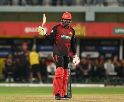
Pravin Tambe who was introduced for the seventh over was not spared by Watson who picked boundaries off his first and last deliveries. Gayle raced to his half century in 26 balls with nine boundaries and a six. Watson became the second wicket to fall when Tambe clean bowled him for 26 with the second ball of the ninth over. Harbhajan also had Finch who went for a sweep and top edged to Tambe for 5. In the last ten overs, World Giants needed 38 runs.
Tambe bowled a brilliant 11th over giving away just one run, beating a well-set Gayle repeatedly. Ross Taylor, going for a slog shot off Yusuf Pathan, fell to a brilliant catch by Raina in the deep for 7. Samit Patel hit back to back boundaries off Raina in the 15th over but he struck to trap Gayle leg before with the last ball of the over for 57.
Yusuf Pathan clean bowled Patel for 12 when 12 runs were needed. Ricardo Powell got run out for 3 and in the end Morne van Wyk hit the winning boundary off Irfan Pathan.
Brief scores: India Maharajas 136 for 9 in 20 overs (Suresh Raina 49, Manvinder Bisla 36; Brett Lee 3 for 18, Chris Mpofu 2 for 22) lost to World Giants 139 for 7 in 18.4 overs (Chris Gayle 57, Shane Watson 26; Yusuf Pathan 2 for 14) by 3 wickets.